
To delve into the topic at hand, accessing an ATM for cash withdrawal requires a financial user to invest an average distance of 35.99 kilometers, taking approximately 38 minutes of travel time by car. It is worth noting that 56.57% of the population has the convenience of an ATM located within a distance of less than 1 kilometer, while 16.66% of individuals need more than half an hour to reach an ATM location.
If you have any additional information or data that could contribute to this discussion, please feel free to leave a comment at the end, providing a link to the relevant data. Additionally, include instructions on how to utilize the information and your assessment of its relevance. Your input will greatly enhance the understanding of the accessibility and convenience of ATMs for financial users.
You can access the spreadsheet with detailed information by clicking here.
When comparing access in Central and Asunción with other departments, we find that the average distance to travel is 1.36 kilometers, taking about 3 minutes to reach an ATM. In contrast, the rest of the country has an average travel distance of approximately 39.04 kilometers and takes around 41 minutes.
To better understand the impact of this difference, we need to consider that Central and Asunción represent about 37.59% of the population, while the remaining 62.40% reside in other parts of the country.
To gain further insight into the situation, let’s examine the following graphs:
When we color the map based on the total population by district, we observe a centralization effect towards Asunción and Central.

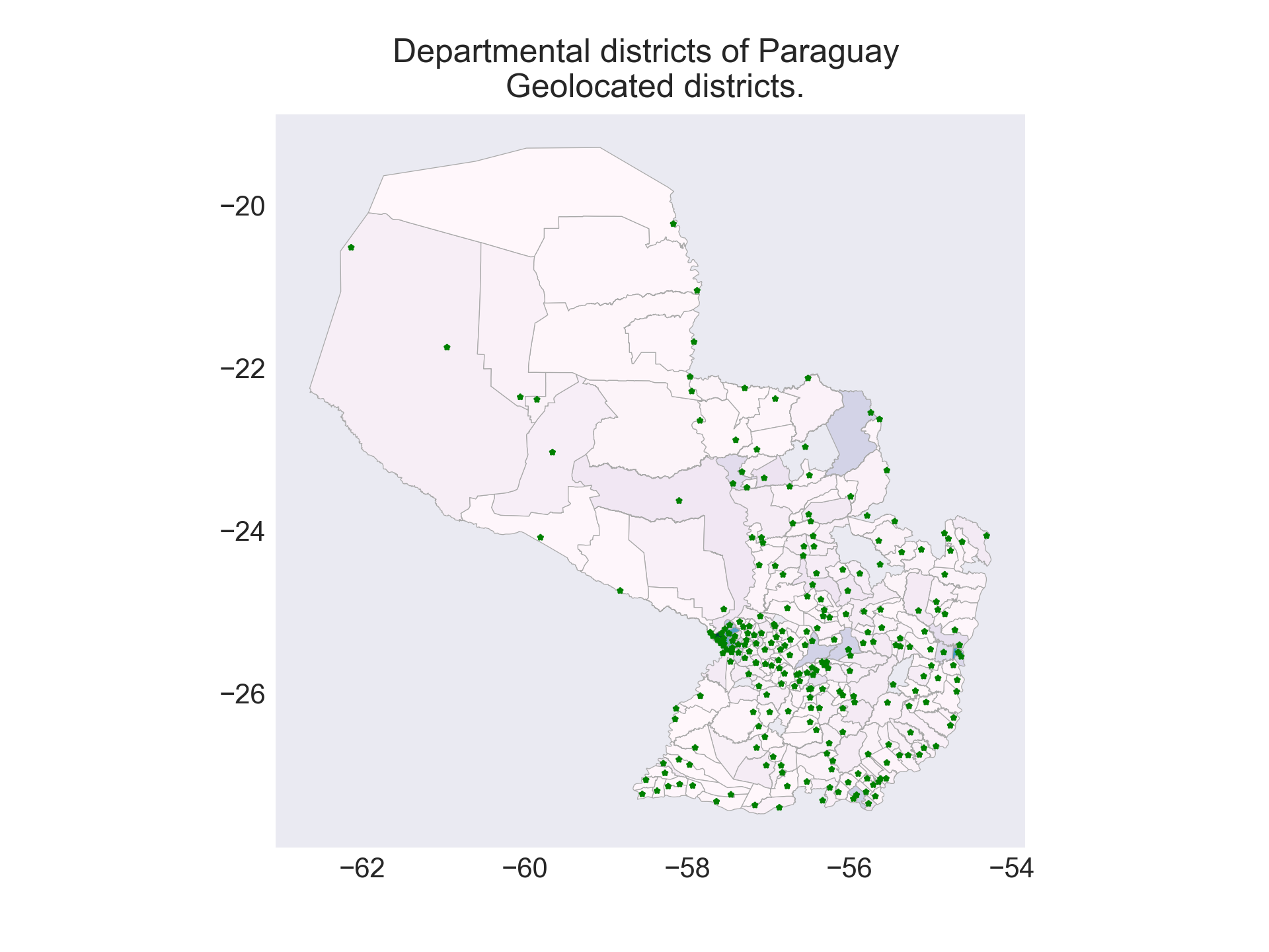
On this map, I have marked the points where Google Maps directs me when I request directions to each district. These points will serve as the starting locations from which we will calculate the distance to the nearest ATMs.
Now, we have added the 2262 geolocated ATMs that we have collected onto the map. Once again, we observe the centralization effect in Asunción and Central. An interesting fact to note is that the time spent traveling to an ATM is 13 times higher for the rest of the country.

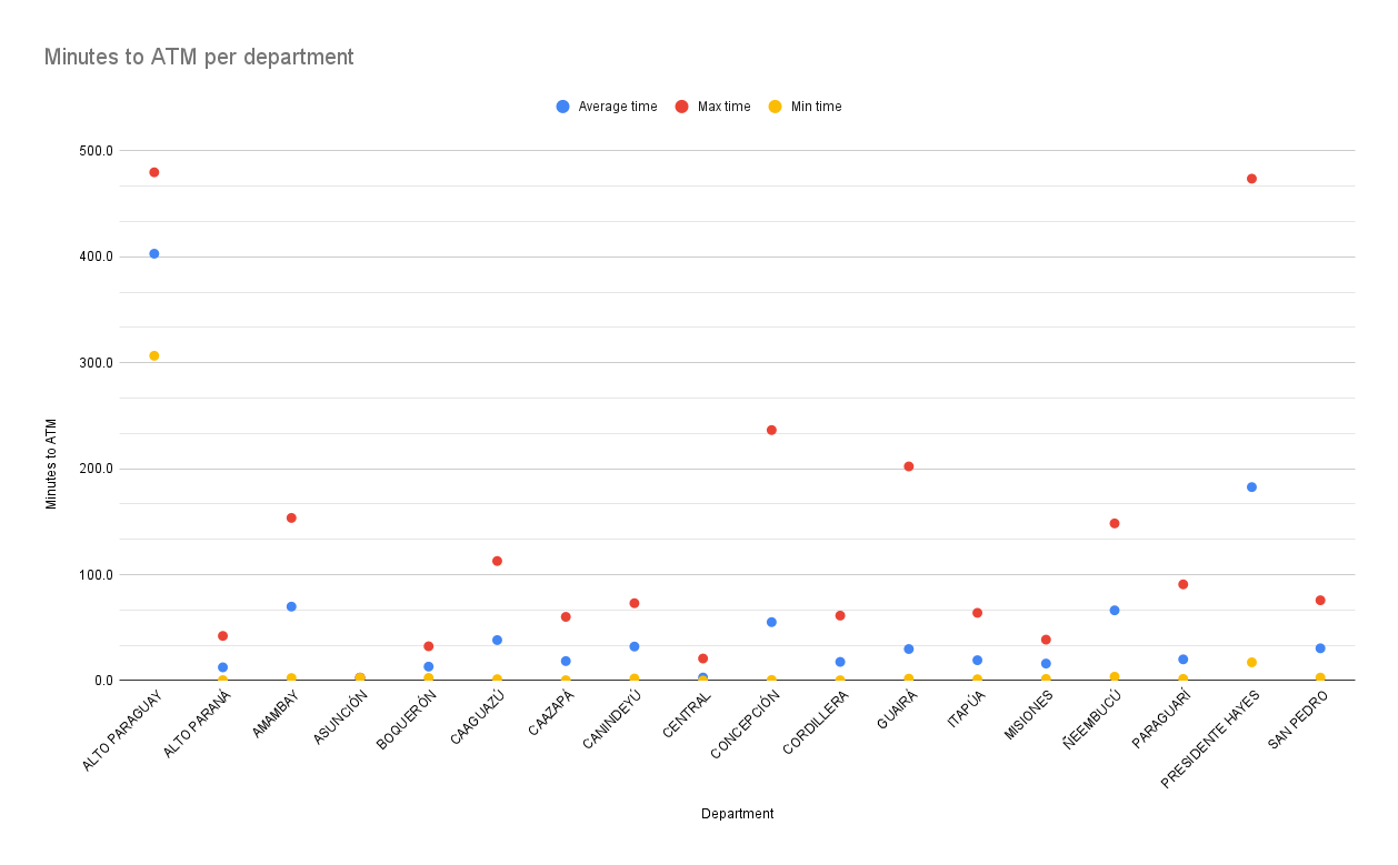
In fact, when we exclusively analyze the travel times between districts within the same department, we find significant variations. Let’s take the example of the department of Concepción. We observe that the average travel time is 55 minutes, with a minimum time of less than one minute and a maximum of almost 4 hours (236 minutes), varying depending on each district within the department. This highlights the importance of considering the specific travel times within each department, as focusing solely on the average travel times would not provide a complete understanding of the reality within that department. For instance, in the case of Concepción, more than 18,000 people spend over an hour just traveling to an ATM.
This information gains context when compared using the indicator proposed by the IMF, which is the Number of ATMs per 100,000 adults.

The scope of this analysis is limited, as it only considers the closest ATMs based on travel time and does not take into account various other factors such as ATM downtime for repairs or refilling, transaction time, or the occupancy level of each ATM, which is likely to be high during salary dates. However, despite these limitations, this analysis provides a brief overview of the current state of affairs.
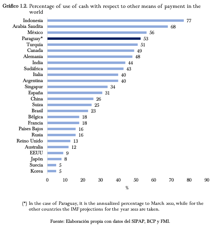
The use of cash plays a central role in our daily economy. In fact, a paper cited in this post examines ATM access in Austria, emphasizing the importance of cash access. Comparatively, in our case, the use of cash is high but not abnormal when compared to other more developed economies like Mexico, Germany, or Canada, as mentioned in this report from the Central Bank of Paraguay (BCP).

Methodology
The first step involved collecting geolocated information from ATMs. Fortunately, both Bancard and Dinelco provide this information to the public on their websites.
Next, we obtained district information directly from the website of the National Institute of Statistics (INE). With this data, we started querying Google Maps for further analysis.
After obtaining a point within each district, we utilized geopandas, a Python library for geographic data, to calculate the three nearest ATMs geometrically to the selected point within each district. This approach allows us to consider alternative ATMs in case a specific one is inaccessible, ensuring that we can determine the ATM with the shortest travel time possible.
Once we have identified the three closest ATMs to each location within the district, we leverage Google Maps to calculate the route to each ATM. We record the distance of each route and the estimated travel time by car.
With the travel times and distances of the three closest ATMs to each district in hand, we proceed to select the ATM with the shortest travel time. This step is accomplished through a pivot table within the spreadsheet that we provided at the beginning of the post.
At this point, we have obtained the information about the closest ATM in terms of travel time and distance. We proceed to copy these values to a separate sheet within the spreadsheet, and I start extracting insights that I find interesting based on the data.
If you find interesting observations in the spreadsheet, please share them in a comment.
For the calculation of distance and travel time, we used the information provided by Google Maps, considering that it corresponds to traffic conditions on a Monday at 11:10 AM. To obtain the districts of Paraguay, we utilized the data provided by Google Maps through its API. The location data for ATMs was obtained from the DINELCO and BANCARD websites, respectively.
Sources and recommended reading:
Departments and Districts of Paraguay
A spatial analysis of access to ATMs in Austria
Central Bank Digital Currency: Implications for Financial Stability and Monetary Policy in Paraguay